
Kennicott, McCarthy
The Kennicott and McCarthy Community Wildfire Protection Planning Area covers from mile 44 to the end of the McCarthy Road at mile 59 and continues 12 miles to the north to include the Wrangell St. Elias National Park and Preserve historic mining site of Kennicott and associated surrounding land. The boundary follows the eastern edge of Root Glacier including parts of Bonanza, Jumbo and Amazon Creek. The planning area wraps around Bonanza Ridge following the McCarthy Creek drainage which includes the McCarthy Creek Road Trail, and continues up to Lubbe Creek and the foothills of the Wrangell Mountains. Continuing south, the edge of this planning area goes around Sourdough Peak following the Nizina River, encompassing both banks to the fork of the Nizina and Chitistone River,the western border follows as far south as Young Creek where it turns east along the Nizina River to the confluence of the Chitina River.
This planning area includes the communities of both McCarthy and Kennicott as well as the university, May Creek and Nizina subdivisions. In 2011 McCarthy and Kennicott adopted their first Community Wildfire Protection Plan and subsequently became an Alaska Firewise Community by educating and adopting Firewise Practices and holding annual Firewise workdays within the community.
Commercially, there are two lodges, a hotel, several flight services, wilderness guide services, rental cabins, bed and breakfasts, campgrounds, various eateries, and a commercial construction company. The road system is made up of narrow gravel roads. There are two privately owned bridges that can be accessed for a fee: one that crosses the Kennecott River into McCarthy, and on that goes across McCarthy Creek to access the University Subdivision. There is a gravel runway located between Kennecott Mine and McCarthy, and several small private air strips throughout the area. Phone services are provided, in town, by Copper Valley Telecom. There is cell phone service through Verizon as well as Copper Valley Telecom. The only internet is via satellite through a variety of different companies. Electricity is provided primarily by way of personal generators.
McCarthy/Kennecott has a volunteer fire department and local emergency medical service providers, however higher levels of medical care and wildfire response are delayed due to its remote location at the end of a 60-mile-long gravel road. A high influx of tourist’s journey to this area during the summer months to enjoy outdoor recreation, fishing, and hiking. This planning area is continuously forested land of spruce and mixed hardwood, and areas impacted by beetle kill from an outbreak in the 1990’s. The surrounding mountainous terrain influences both wind and weather, with winds often funneling down the drainages. This area holds a rich history deeply embedded with cultural and historic mining sites.


CWPP Planning Area Map

Community planning areas include the wildland urban interface (WUI), defined as the area where human development meets and intermingles with undeveloped wildland and vegetative fuels. Included are lands designated as “Critical” and “Full” fire management options. Fire management options are assigned by jurisdictional agencies (landowners/managers), while protection agencies provide fire suppression responsibilities and initial response to wildfires. Alaska Division of Forestry and Fire Protection is the protection agency responsible for fire suppression in the Copper River Basin. See https://forestry.alaska.gov/fire/fireplans for more information on fire management options.
The goal of creating a community wildfire protection plan is to reduce the potential for disaster within the planning boundary by recognizing the hazards, prioritizing areas of protection, and developing a workable action plan with clear goals and objectives to mitigate the risks from wildfire, life, and property.
Explore the CWPP Planning Map App. with useful planning layers including CWPP areas, fire management options, land ownership, vegetation layers, and fire return interval models. .
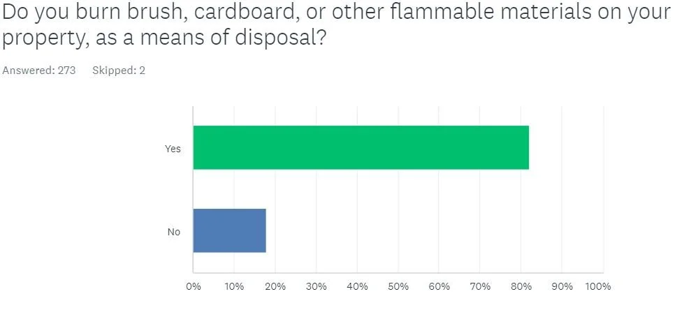
Community Wildfire Protection Plan Survey results:
Thank you for participating


Notes from past meetings
The First meeting for the Kennicott/McCarthy area was combined with 2021 Fall MAC meeting and was not recorded. Please reach out to Emily Hjortstorp at 907-822-5534 if you have questions regarding this meeting.