
Mendeltna, Nelchina
The Mendeltna / Nelchina Community Wildfire Protection Planning Area covers from mile 161 to 135.5 of the Glenn Highway. This planning area connects with the Tolsona / Lake Louise planning area to include the confluence of the Nelchina River to Tazlina Lake, as well as Twin Lakes near the south western border, the Little Nelchina River, Slide Mountain, John Lake, Old Man Lake, Nickoli Lake and Fish Lake, accessible from the north side of the Glenn Hwy. The eastern border is on the east side of Lake Louise Road, including the road to mile 8.5. Many trails, some of them winter use only, cross the landscape to reach recreational properties and hunting and fishing grounds. Several full time residents live on the south side of Slide Mountain and along the highway corridor. Multiple businesses in the area including a lodge, rental cabins, and three stores. The Tazlina airstrip, and Tazlina-Smokey Lake Seaplane base are located at mile 156 on the Glenn Hwy. Vegetation types in this region include black spruce in poorly drained low lands, large expanses of continuously forested areas of spruce and mixed hardwood, some areas which were impacted by beetle kill from an outbreak in the 1990’s, and boreal mesic shrubs/dwarf trees on ridgeline/higher elevation areas. Lying just outside this planning area are several fire scars. One being a 6,700 plus acre scar from the Tazlina Lake Fire in 1991. In 2019 the Tokiana Fires (multiple lightening starts) burned on the eastern side of Tazlina Lake leaving behind burn scars totaling more than 14,900 acres.
Mendeltna was originally a stop on the trail from Lake Tyone to Tazlina Lake, used by the Athabaskan people. In the 1800’s gold was discovered in the creeks draining from the Chugiak Mountains attracting prospectors to the area. Nelchina, a nearby community – also represented in this CWPP, was a mining settlement established in 1913. It was not until 1915 that these towns were first reported by the U.S. Geological Survey. Land ownership in this area includes private, state, BLM, village and tribal corporation lands, and native allotments. This area holds a rich history deeply embedded within the Athabaskan and Ahtna peoples.
We are currently in the process of creating a CWPP for the Mendeltna / Nelchina planning area. It will be available here once it is published.


CWPP Planning Area Map
Community planning areas include the wildland urban interface (WUI), defined as the area where human development meets and intermingles with undeveloped wildland and vegetative fuels. Included are lands designated as “Critical” and “Full” fire management options. Fire management options are assigned by jurisdictional agencies (landowners/managers), while protection agencies provide fire suppression responsibilities and initial response to wildfires. Alaska Division of Forestry and Fire Protection is the protection agency responsible for fire suppression in the Copper River Basin. See https://forestry.alaska.gov/fire/fireplans for more information on fire management options.
The goal of creating a community wildfire protection plan is to reduce the potential for disaster within the planning boundary by recognizing the hazards, prioritizing areas of protection, and developing a workable action plan with clear goals and objectives to mitigate the risks from wildfire, life, and property.
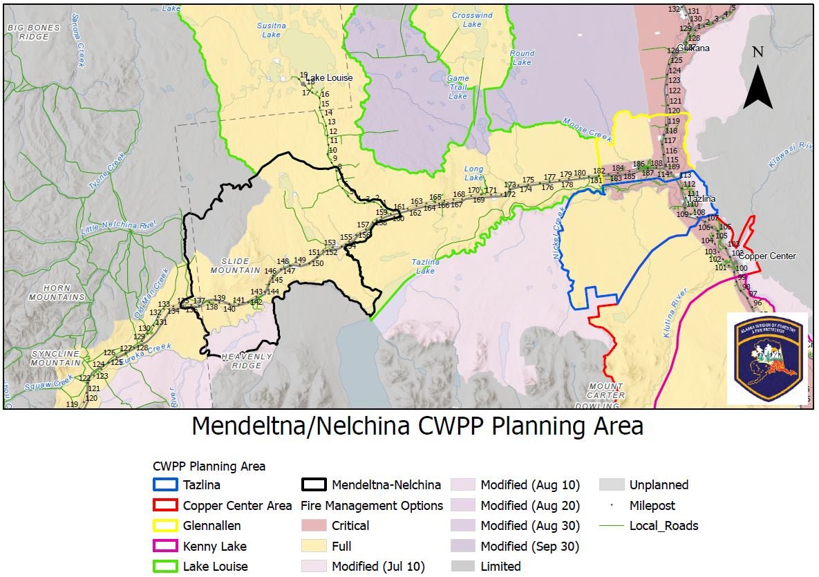
Explore the CWPP Planning Map App. with useful planning layers including CWPP areas, fire management options, land ownership, vegetation layers, and fire return interval models. .
Community Wildfire Protection Plan survey results:
Thank you for participating


1st Mendeltna, Nelchina Meeting
Notes from past meetings
There are no past meetings’ notes yet.