
Kenny Lake, Willow Lake, Tonsina
The Kenny Lake Community Wildfire Protection Planning Area is a large area of over 100,000 acres encompassing several communities from mile 99.5 to 58 on the Richardson Highway and extends from mile 0 to 20.5 on the Edgerton Hwy. This planning area includes vast amounts of urban interface with developed residential areas scattered amongst various natural features and agricultural developed land.
Following the Richardson Hwy, one will find new and expanding agricultural parcels on the west side around mile 94. The stretch of highway from here to Willow Lake includes other agricultural areas, several residential areas, at least 2 year round businesses and many homes around Willow Lake itself. Many of the residential roads are poorly marked and maintained in this area. The Old Edgerton Hwy connects this stretch of highway with mile 7 of the Edgerton Hwy and is a narrow gravel road through a heavily wooded area, containing spruce and aspen forest with many residents along it. The agricultural community of Kenny Lake spans the Edgerton Hwy to Lower Tonsina, where the confluence of the Tonsina and Copper Rivers can be found. The Kenny Lake K-12 school, local volunteer fire department, two community wells, emergency medical service ambulance garage, community hall, and several businesses are along this stretch of road, not to mention hundreds of acres of hay fields, livestock fields, and homes lining the road corridor. Pippen Lake, where the Edgerton Hwy meets the Richardson Hwy contains several residences around the lake with pipeline access roads behind it. Continuing south, the area encompasses Squirrel Creek and Upper Tonsina where the Tonsina River crosses the Richardson Hwy, and contains several residents, at least 2 businesses, and a state campground/recreation area. Further south, the highway follows the heavily vegetated river valley of the Little Tonsina and Tiekel Rivers. Residents are spaced further apart and both Alyeska Pipeline and Alaska Department of Transportation infrastructure facilities can be found. The Richardson Hwy corridor also contains the high transmission power lines which supply the Copper River Basin with Power from Valdez.
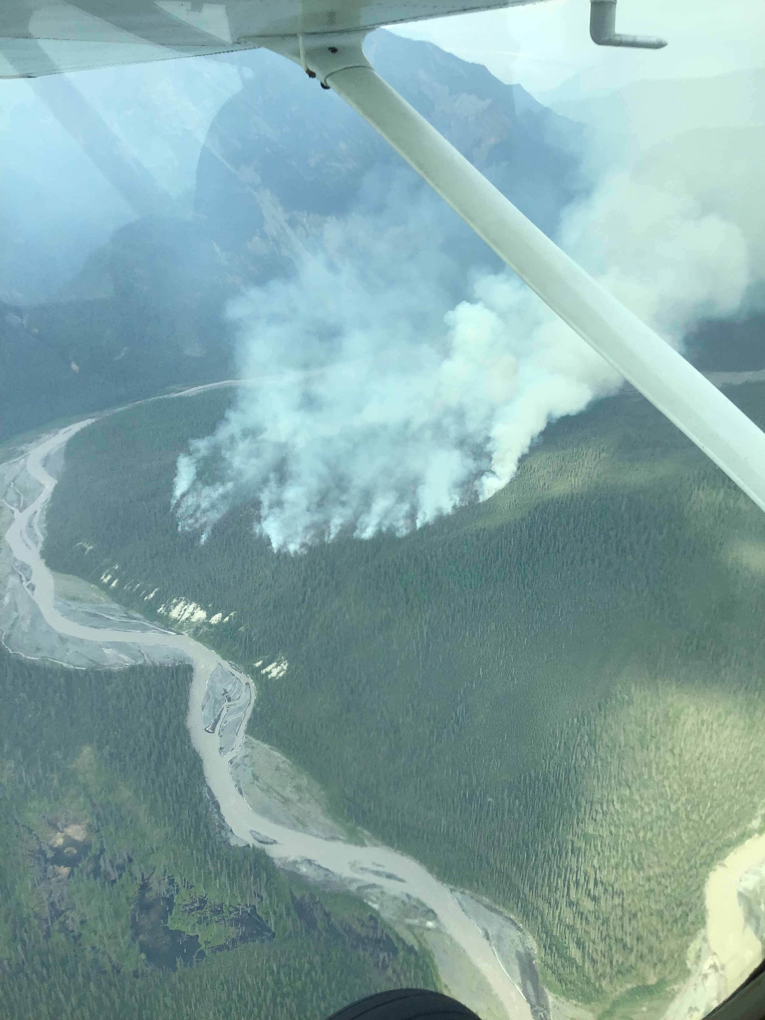
Land ownership in this area includes private, state, BLM, Ahtna, BIA, village and tribal corporation lands, as well as native allotments. Most of this planning area is continuously forested land of spruce and mixed hardwood and areas of black spruce broken up by several large lakes and agricultural development. Springtime, pre green-up is a concern for the fine fuels found in hay fields, particularly if they have not been cut in the fall, as fire travels rapidly through dry grass. However, in summer, agricultural fields act as valuable fuel breaks in heavily forested areas. Some stands of spruce are impacted by beetle kill from an outbreak in the 1990’s. There is a 3,700 plus acre fire scar, now regrown with regeneration trees along the Edgerton Hwy extending to Lower Tonsina from the Edgerton Fire in 1969. Other older fire scars can be found north of the Edgerton Hwy. to the Copper River from early 1900 settlers attempting to set fire to the land to clear it. This was not an effective land clearing method.
We are currently in the process of creating a CWPP for the Kenny Lake, Willow Lake & Tonisina planning area. It will be available here once it is published.


CWPP Planning Area Map
Community planning areas include the wildland urban interface (WUI), defined as the area where human development meets and intermingles with undeveloped wildland and vegetative fuels. Included are lands designated as “Critical” and “Full” fire management options. Fire management options are assigned by jurisdictional agencies (landowners/managers), while protection agencies provide fire suppression responsibilities and initial response to wildfires. Alaska Division of Forestry and Fire Protection is the protection agency responsible for fire suppression in the Copper River Basin. See https://forestry.alaska.gov/fire/fireplans for more information on fire management options.
The goal of creating a community wildfire protection plan is to reduce the potential for disaster within the planning boundary by recognizing the hazards, prioritizing areas of protection, and developing a workable action plan with clear goals and objectives to mitigate the risks from wildfire, life, and property.

Explore the CWPP Planning Map App. with useful planning layers including CWPP areas, fire management options, land ownership, vegetation layers, and fire return interval models. .
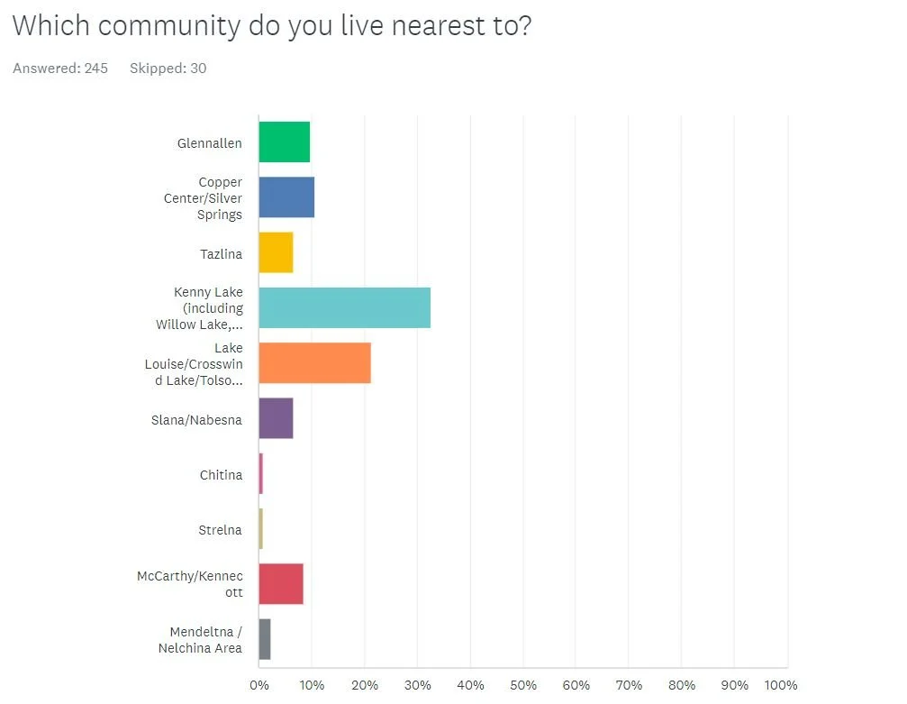
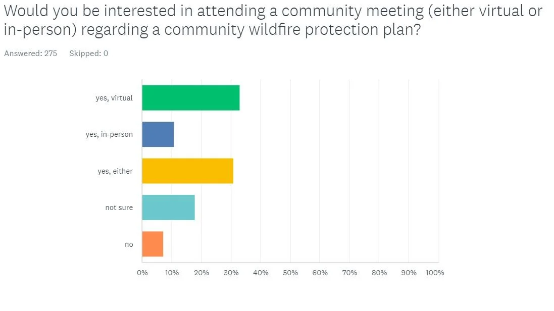
Community Wildfire Protection Plan survey results:
Thank you for participating


1st meeting in Kenny Lake
Notes from past meetings
There are no past meetings’ notes yet.